New technology helps find water underground in California
FRESNO, Calif. (KSEE/KGPE) – California is deploying cutting-edge technology that can ‘see’ underground water. A giant electrified ring suspended from a helicopter will make a never-before-seen picture of a world beneath our feet.
Wells in the Valley are running dry. Drilling deeper is more expensive and sometimes still fails to find water.
When it does, water quality is often worse, containing minerals like arsenic.
General Manager of Yolo County Flood Control Kristin Sicke says, “Groundwater is an extremely important critical reserve during dry years.” The California Department of Water Resources says groundwater makes up nearly 60% of the state’s entire water supply during drought.
Subsidence or sinking land is an infrastructure problem from canals to roads to bridges.
Groundwater naturally recharges over time but not where subsidence occurs. It collapses the spongy rock that can hold water underground.
Our current knowledge of groundwater is based on how deep wells are drilled before water is found.
The state shares this data through its SGMA Data Viewer, but the picture is incomplete.
California Department of Water Resources Director Karla Nemeth says an Airborne Electromagnetic Survey is “one of many new technologies the Department is implementing in addition to forecasting improvements.”
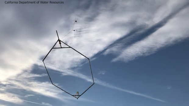
Just like doctors use an MRI to ‘see’ organs and bones inside your body, California is using new Airborne Electromagnetic Survey technology – or AEM – to ‘see’ water underground.
It’s an electrified coil – a giant metal ring the size of a building.
A helicopter suspends this ring above the ground. The readings create an image of underground features including water.
The California Department of Water Resources will use AEM to map the water underground. This will provide a never-before-seen picture of where water is, how much there is, where it is rising and where it is falling.
It will take three years to map all the basins through Central California.
Residents will be informed before flights take place in their area. Information on the process as well as all data gathered will be shared with the public through the AEM web page.


Gloss