SDSU ag researchers expand technology with $100,000 drone
https://www.ispeech.org/text.to.speech
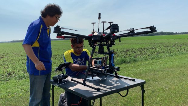
BROOKINGS, S.D. (KELO)– The SDSU research team welcomed their research grade hyperspectral sensor drone to their research project, around a $100,000 dollar investment that will help to enhance their knowledge of using drones in their fields.
SDSU has had the new drone for around a month, and they have been collecting information targeted on nitrogen stress in production agriculture and focusing on if there are ways they can do a better job with their no-till systems. They have also been looking into if drone technology could replace soil sampling.
Drones detect different color bands when collecting data. This new drone will help researchers determine what bands they should be focusing on when analyzing the data to look for things such as plant stress.
On the more common sensor drones, they have a few sensors and there is a broad color band in each sensor, said Jiyul Chang, Lecturer for Precision Agriculture, but the hyperspectral sensor drone has very narrow bands and each sensor has 300 to 400 different bands, making data more detailed and precise.
The sensor on the drones are different than the cameras on a cell phone, Chang said. The cell phone camera only takes metrocolor images, because it only has blue, green, and red bands. But the drones us the Near Infrared band, and it is very sensitive at detecting the plant healthiness.
“If a plant is not very much healthy, reflections of Near Infrared is low,” Chang said. “But if the plant is very healthy, reflections of a Near Infrared is high. So when you take the images, using this multispectral band Near Infrared [we] cannot see this type of difference, from the imagery we can find out which plant is healthy and which plant is not healthy.”
“As we think about what drones do and what we are collecting, drones collect information that we cannot see,” said David Clay, Distinguished Professor of Soil Biogeochemistry. “When we started collecting, perhaps in the 1970s, we start with information that might be very similar to collecting information from the blue band or from the green band.”
The information that they are collecting with a drone of a UAV, is similar to a the bands that you see when you look at a rainbow, Clay said, and they separate it into the individual color bands. When they are looking at their soils or their crops, they can see the data based on what the blue, green and red bands are, but there is other information out there.
“If I look at longer wavelengths or if I look at shorter wavelengths, there’s information that’s collected that we can’t see and so as I start thinking about how I can use this information, one of the thoughts are we can use information like what the drone is providing to identify how much soil organic matter you have in your field, how that varies across your landscapes, how that is going to influence your crop productivity or how that is going to influence your water and run-off erosion problems,” Clay said.

But Clay says the first question they need to ask is “what bands do we need to collect?”
The hyperspectral scanner in the new drone is designed to answer that question for different specific problems the crop is seeing.
For example, if he is interested in look at crop diseases, Clay said it might be different bands than if he is looking at water stress.
There is also a lot of interest in carbon markets right now, and part of that information is how much carbon has the soil increase, Clay said, so that is something they can look for with this new technology. Nitrogen stress is also another issue that they are looking to detect, in order to apply fertilizer as cost efficiently as possible. They are also looking at diseases and targeting fungicide applications.
“The drone information will provide information as we start trying to target where we have problems from other areas that don’t necessarily have those problems,” Clay said.
This specific drone was not designed for farm application, Clay said. It was created for research about how and what information needs to be collected. The information that they are currently collecting with drones was based on decisions that were made in the 1960s.
Once they decide what bands and information are important, then they can figure out how they develop a drone, perhaps with a fixed wing system, that might collect slightly different data but provide the information that is more useful to farmers, Clay said.
With the current technology, it can be difficult to tell the difference between water and nitrogen stress, Clay said, which are two problems that a producer does not want to get confused when it comes to helping fix that stress.
SDSU currently has two other types of drones: a fixed wing drone, which costs about $13,000 which SDSU uses for field scouting and a small helicopter sensor drone, which is the most commonly used among farmers and costs $3,000 to $5,000.
-
small helicopter sensor drone -
fixed wing drone


Deepak Joshi, PhD student at SDSU, said that they use the fixed wing drone for field scouting fields around 100 acres and they can get pictures of the whole field. The new hyperspectral sensor drone is for smaller test plots.
The different sensors were designed for different purposes, Clay said. When conducting research, they have different people using different sensors and they collaborate to solve the common problems.
Precision data technology is not something new to SDSU, Clay said. It started with flying a field in a plane, getting the information on a CD and processing it in the laboratory. This process took multiple days before they had the information. The same applies for their satellites. The drones make the information immediately, which is critical for decision making.
What the drones do right now to help farmers, is to locate the area in the field that they need to look to find the problems with their crop, Clay said, rather than having to walk the field on foot or just drive by. This reduces the labor requirements for farmers, by around 80 percent, and gives them better information.
“That is where we are at right now,” Clay said. “Where we want to go is ‘how do I use that drone information to combine with variable rate equipment to target application’ and a big part of that is identifying the stressors.”
Right now, the drones can’t, Clay said, but this new drone will help with that, speeding up the process and making production agriculture more profitable.
“Our cost imputes are so high we can’t afford to wait on making decisions in our production field,” Clay said.
Joshi said the drones really cut down on time.
“Scouting a whole quarter section is almost like it will take me whole, more than a day probably, but with a drone its less than a twenty minute work,” Joshi said.
Drone technology is becoming more popular around farmers, whether they are using the technology themselves or hiring an agronomist to do it for them.
In Chang’s precision ag class, he says he sees many students who are interested in using drone technology on their operation to save time, money and get the data they need during the growing season.
Get the latest KELOLAND News headlines, weather forecasts and sports updates delivered to your email inbox. Click here to sign up!


Gloss