New Snow Survey technology could change how we manage water resources
FRESNO COUNTY, Calif. (KSEE) – Results from the latest Sierra Snow survey are not encouraging, which is no surprise.
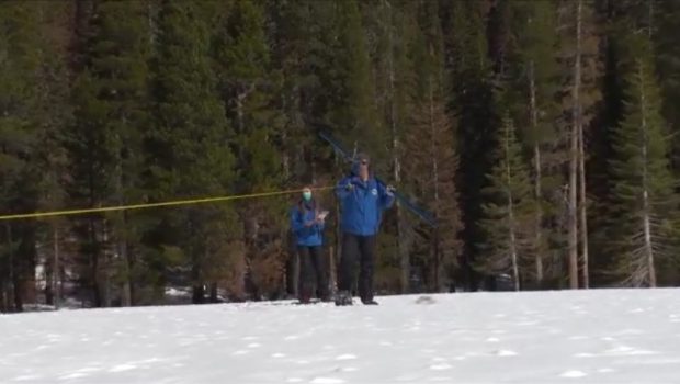
The State of California established Cooperative Snow Surveys 93 years ago. New technology is getting put to use to better survey mountain snow, provide better forecasts and help eliminate waste.
“Over 260 different snow courses that are measured statewide by different cooperators of the California Cooperative Snow Surveys Program,” California Department of Water Resources Snow Surveys and Water Supply Forecasting Unit Manager Sean de Guzman said.
Each month, the Sierra Nevada Snowpack is measured in the same exact same places using the exact same methods. Standardized tools and consistency allow scientists to use a few measurement points to estimate the overall snowpack and compare different years.
“Our statewide snowpack is 63% of the average based off of our automated snow sensor network,” Guzman said.
Results tend to vary throughout different parts of the Sierra Nevada Mountain range.
“Unfortunately, they reflect what we all know, that this is a very, very dry year. On the Kings River watershed, There are 23 stations that have been reported so far for March 1st and they are showing a snowpack water content of 15.4 inches. Now, that is 68% of what it should be for this time of year,” Kings River Water Association spokesperson Randy McFarland said.
Nearly a century of this carefully-gathered data is the foundation of what we know about snowpack, but there’s a lot more to know.
“Our typical snow surveys occur between about 7500 foot of elevation and about 11,000 foot of elevation. About 20% of our watershed lies above our highest course. So we have no idea what’s up there,” Kings River Water Association Watermaster Steven Haugen said.
For the first time, the Kings River Water Basin is about to get a comprehensive set of snowpack measurements covering every square using an aircraft-mounted laser. The aircraft flies a pattern over the mountains like mowing a lawn.
“The observations that were made from the flight over the watershed showed that there were large bear areas on the southern and eastern slopes. So since none of those were evident in the snow survey, we really expect the actual snowpack water content is somewhat less,” McFarland said.
Each flight produces around a terabyte of data, and results require days of computer processing. Each successful survey is expected to reveal new knowledge.
“That allows us to much better utilize our facilities, our structures, timing of irrigation deliveries, timing of flood releases, and has a whole host of benefits. So it will change water management.”Haugen said.


Gloss