
Google Maps is a hugely useful tool that’s used by millions of people around the globe, mostly thanks to its excellent navigation and traffic tools. Recently, though, someone had the bright idea to “hack” Google Maps by creating virtual traffic jams using a wagon full of smartphones.
If you’ve ever used Google Maps in a remotely busy area, you’ve probably come across intersections where an accident or construction slowed down traffic a fair bit. When that happens, Maps changes the color of the affected roads from green to either orange or red to show how bad the traffic is and, if things get bad enough, it will even find another route for its users.
To figure out how bad traffic is, Google uses other people with Maps to identify areas of heavy traffic or slow-moving traffic. The more people using Google Maps in one area, the worse the traffic probably is and, in turn, Google changes the color of the street to show that.
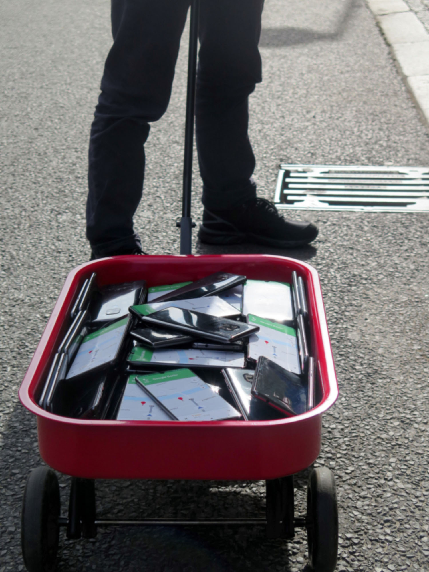
Simon Weckert recently took advantage of that process with a “hack” – as he calls it – for Google Maps. To accomplish this, he loaded 99 smartphones into a wagon and turned them all onto Maps navigation. As he walks down a street, Google recognizes the high concentration of “users” and the slow-moving “traffic” and marks that street as having bad traffic.
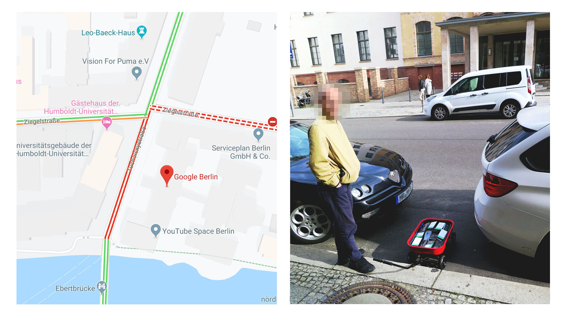
Somewhat hilariously, this would actually cause other drivers in the area using Maps to be re-routed to avoid the “traffic” caused by this otherwise harmless prank. Weckert even took the collection of smartphones right outside of Google’s Berlin offices to create the virtual traffic jam.
99 second-hand smartphones are transported in a handcart to generate virtual traffic jam in Google Maps. Through this activity, it is possible to turn a green street red which has an impact in the physical world by navigating cars on another route to avoid being stuck in traffic.
Hopefully, Google will take measures to prevent this sort of thing in the future since this could probably be abused by someone with the right resources.
Granted, it’s important to note that it’s entirely possible this is being faked – the methodology isn’t clearly explained in the post, after all. We’ve reached out to Google to see if the company has any measures in place to prevent abuse of this sort of thing.
Update 2/3: Speaking with 9to5Google, a spokesperson from Google has responded to this situation to clarify a few things. In normal usage, Google does use a large number of devices running Maps in a single place as proof of a traffic jam, something this rare and very specific case took advantage of. In the statement below, though, the company does hint that it might use cases like this to further improve how Maps handles traffic data.
Whether via car or cart or camel, we love seeing creative uses of Google Maps as it helps us make maps work better over time.
Traffic data in Google Maps is refreshed continuously thanks to information from a variety of sources, including aggregated anonymized data from people who have location services turned on and contributions from the Google Maps community. We’ve launched the ability to distinguish between cars and motorcycles in several countries including India, Indonesia and Egypt, though we haven’t quite cracked traveling by wagon. We appreciate seeing creative uses of Google Maps like this as it helps us make maps work better over time
Google also mentions that its systems are continuously refreshed from a variety of sources and that it’s committed to providing the most comprehensive and accurate maps possible. The company also highlights, somewhat jovially, how it can distinguish between cars and motorcycles in some regions, but it hasn’t cracked wagons just yet.
More on Google Maps:
FTC: We use income earning auto affiliate links. More.
Check out 9to5Google on YouTube for more news:


Gloss